Understanding the impact of El Niño on the variability of the global shoreline position

The interannual evolution of coastlines on a global scale is dominated by El Niño. This is demonstrated by a study conducted by several research organizations, including IRD and CNES, published in Nature Communications.
More specifically, researchers highlighted the influence of the climatic and oceanographic phenomenon ENSO (El Niño—Southern Oscillation) on coastlines on a global scale. To reach this conclusion, scientists used, for the first time, satellite data obtained between 1993 and 2019 on shoreline and sea levels positions, as well as global numerical model products.
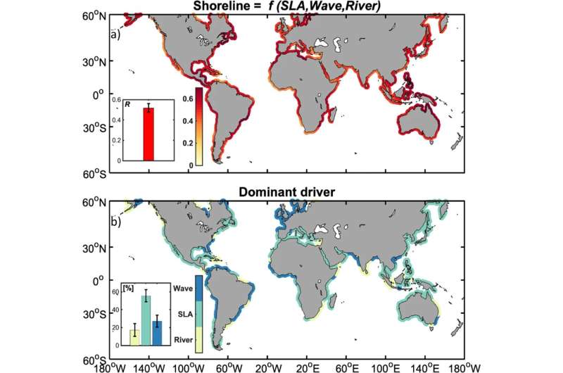
These data revealed that shorelines are impacted by three main factors: sea level, oceanic waves and rivers. El Niño has a direct impact on these factors. The results of this study have created a new framework for understanding and preventing coastal risks caused by the climate.
Coastal areas are fragile and complex dynamic systems that increasingly threatened by the combined effects of anthropogenic pressure and climate change. While sea level directly affects coastal mobility, waves have an impact both on erosion and accretion as well as on water levels during storms. Rivers, on the other hand, affect coastal sediment availability and water level variations induced by changes in salinity.
To carry out this study, the researchers observed the evolution of coastlines around the world over a period of almost thirty years, using satellite observations (Landsat) and high-performance Cloud-based calculations. The outcome provided the first global vision of shoreline evolution. This satellite data was linked to climate forcing by observations of the sea level along the coast (satellite altimetry conducted by CNES and the AVISO+ data platform), models of waves and river flows.
Using a global conceptual model that takes into consideration the influence of the key modes of climatic variability on these factors, researchers found that interannual changes in the shoreline are largely determined by different ENSO episodes and their complex teleconnections between basins.
This study demonstrates the predictability of shoreline evolution on interannual scales in an intertropical band particularly subject to climatic hazards. It also highlights the benefits of using increasingly precise and frequent satellite observation data, available free of charge, on coasts that are often poorly documented. These data are invaluable tools for decision-making and anticipating coastal risks, particularly in the event of a major climatic event such as the next El Niño expected at the end of 2023.
On a decadal or centennial time scale, sea-level rise and the influence of rivers will dominate over waves, which are expected to show more contrasting trends worldwide. Consequently, understanding and forecasting shoreline evolution is significant in the management of coastal areas. This means that potential threats can be anticipated so there is enough time to implement effective adaptation measures.
More information:
Rafael Almar et al, Influence of El Niño on the variability of global shoreline position, Nature Communications (2023). DOI: 10.1038/s41467-023-38742-9
Provided by
Institut de Recherche pour le Développement (IRD)
Citation:
Understanding the impact of El Niño on the variability of the global shoreline position (2023, June 12)
retrieved 12 June 2023
from https://phys.org/news/2023-06-impact-el-nio-variability-global.html
This document is subject to copyright. Apart from any fair dealing for the purpose of private study or research, no
part may be reproduced without the written permission. The content is provided for information purposes only.
For all the latest Science News Click Here
For the latest news and updates, follow us on Google News.

