Study offers new approach to conduct large-scale protection assessments of Marine Protected Areas (MPAs)

A new study offers a science-based method to assess protection levels in marine protected areas (MPAs) when information on regulated human activities is limited. The study, recently published in the journal Marine Policy, provides a new technique to inform progress towards international conservation goals, including protecting 30 percent of marine areas by 2030, which was adopted in Dec. 2022 at the UN Biodiversity Conference in Montreal, Canada, known as COP15.
Marine protected areas are an important tool to conserve marine biodiversity, but assessing the level of protection for MPAs can often be difficult due to limited regulatory information on human activity.
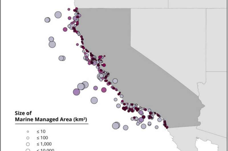
The analysis, based on real-world scenarios using MPAs and other managed areas in California, showed that the ProtectedSeas Navigator‘s Level of Fishing Protection (LFP) score can help guide assumptions about whether specific fishing methods required for assessments are likely allowed or prohibited when those methods are not mentioned in management plans.
The LFP guidance reliably identified areas that scored highly or fully protected under a full analysis, when combined with assuming unknown non-fishing activities such as aquaculture and bottom exploitation, to be “prohibited”, and when combined with unknown activities such as boating, anchoring, and fishing activities, to be “allowed.”
“This case study illustrates how Navigator is a valuable resource to estimate progress towards 30×30. These findings show that Navigator can accelerate MPA review and help guide assessment decisions even when information is incomplete,” said ProtectedSeas Director Virgil Zetterlind, a co-author of the study.
In the first set of scenarios in this analysis, information available in direct management plans was applied to the Regulations Based Classification System (RBCS). Ninety-nine and 100 percent correct classification of fully and highly protected areas respectively under the RBCS was obtained when unknown activities such as aquaculture, bottom exploitation, and bottom extraction were assumed “prohibited”; while unknown and boating, anchoring, and fishing activities were assumed as “allowed.”
In the second set of scenarios, the researchers used only information available in the ProtectedSeas Navigator that matched those in the RBCS with no additional research. They found that the accuracy remained high, with 92 and 94 percent of fully and highly protected areas respectively classified correctly when using assumptions for fishing activities assisted by the Navigator’s Level of Fishing Protection score.
The RBCS predicts MPA effectiveness based on the types of human activities allowed and their relative impacts on the marine environment. While comprehensive, these assessments are resource-intensive as they require significant knowledge about a wide range of fishing methods and human activities that are often managed by different authorities.
ProtectedSeas Navigator captures more than 50 individual attributes of protected areas including the allowed or prohibited status of eight different fishing gear and 10 other human activities. Navigator’s LFP scoring system uses an easy-to-follow decision tree that does not require a complete set of fishing and activity restrictions to assess a 1 to 5 score.
ProtectedSeas Navigator is the most comprehensive database of marine life protections and their boundaries available. Navigator provides a free, interactive map of regulatory information for MPAs and marine managed areas (MMAs) in over 22,000 marine areas for coastal and island countries and the high seas, and the complete set of Navigator data is available in many formats and channels to support assessment, planning, and analysis.
“Using standardized, scientifically validated methods to assess global progress towards the UN 30×30 target is critical to ensuring effective conservation and not just creating more paper parks,” said Zetterlind. “Navigator can help the marine conservation community understand where they need to go to create protections.”
More information:
Alex Driedger et al, Guidance on marine protected area protection level assignments when faced with unknown regulatory information, Marine Policy (2022). DOI: 10.1016/j.marpol.2022.105441
Provided by
ProtectedSeas
Citation:
Study offers new approach to conduct large-scale protection assessments of Marine Protected Areas (MPAs) (2023, February 2)
retrieved 2 February 2023
from https://phys.org/news/2023-02-approach-large-scale-marine-areas-mpas.html
This document is subject to copyright. Apart from any fair dealing for the purpose of private study or research, no
part may be reproduced without the written permission. The content is provided for information purposes only.
For all the latest Science News Click Here
For the latest news and updates, follow us on Google News.

