Dozens of roads are closed across Queensland due to widespread flooding, with the Bruce Highway and other main roads impacted.
Dozens of roads in Queensland are closed due to flooding after heavy rain fell across the state due to ex-tropical cyclone Seth.
Queensland Traffic has warned drivers to expect long delays in some areas after flooding led to the closure of more than 85 roads.
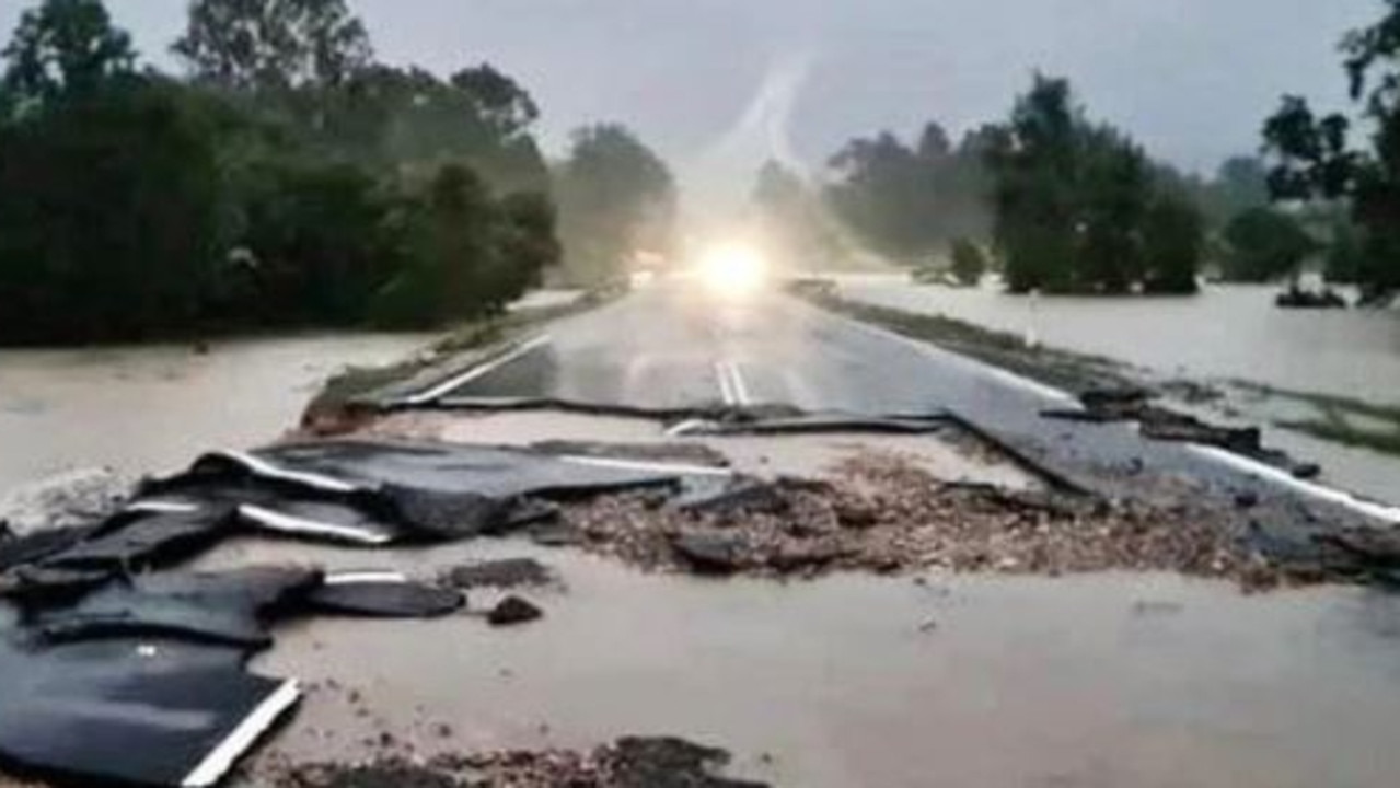
Parts of the Bruce Highway appear to have been washed away near Curra, with motorists urged to seriously reconsider travel plans.
Other highways impacted include the Burnett, Carnarvon, Castlereagh and Leichhardt.
Queenslanders have been warned to brace for more wild weather with more than 650mm of rain already falling at Mt Kanigan, 200km north of Brisbane.
Residents in the nearby town of Gympie were issued a major flooding alert at 7.30am on Saturday, with all motorists advised to stay off the roads.
Cars have also been washed off the roads and houses flooded, with rescue teams deployed to hardest hit areas on Friday night.
Here is a list of some of the road closures as of 11am, updated details available at www.qldtraffic.qld.gov.au
• Bruce Highway, Benaraby
• Bruce Highway, Marlborough/Ogmore, potholes and rough surface due to wet conditions.
• The Cedars Road (Burnett River Bridge), South Kolan, water over road
• Gympie Woolooga Road, Little Channon Street, Gympie/Southside at Kidd Bridge
• Tin Can Bay Road, Victory Heights at Moody Creek
• Wide Bay Highway, Lower Wonga, near Abels Road
• Louis Bazzo Drive (Six Mile Creek Bridge), Pomona, flash flood at Six Mile Creek Bridge
• Louis Bazzo Drive, Pomona, flash flooding at Cooroora Creek Bridge
• Ward Road, Tambo/Ward, Tambo to Ward (Tambo to Murweh Council boundary)
• Quilpie Adavale Road, Adavale, Blackwater Creek 1km east of Adavale
• Ravensbourne Road, Blackall, Blackall – Ravensbourne
• Mount Playfair Road, Mt Playfair Road, Caldervale/Carnarvon Park/Tambo, Tambo to Carnarvon Park
• Carnarvon Highway, Noorindoo, approximately 1km north of Surat
• Castlereagh Highway (Dirranbandi Hebel Road), Dirranbandi, from 11km south of Dirranbandi to 25km north of Hebel
• Leichhardt Highway, Goondiwindi, Billa Billa Creek
• Marlborough Sarina Road, May Downs Road, Clarke Creek/May Down, whole road
• Langlo Road, Langlo/MacFarlane, Tambo to Langlo (Tambo to Murweh council boundary)
• Dawson Developmental Road, Windeyer, Tambo to Springsure via Windeyer (Tambo to Central Highlands council boundary)
• Mungar Road, Tiaro, Mary River Bridge
• Eumundi Kenilworth Road, Gheerulla, Pioneer Park
• Gympie Woolooga Road (Woolooga Road), Widgee, at Litttle Widgee Creek Bridge
• Burnett Highway, Goomeri, Chippendale Creek north of Goomeri has cut the highway
• Gray Street, Kennedy Developmental Road, Hughenden/Lyndhurst, open with caution
• Burke Developmental Road, Rookwood, Fergusons Crossing
• Burke Developmental Road, Wrotham, Trimbles’s Crossing
• Burke Developmental Road (Lynd River Bridge), Gamboola, flooding – water over road
Originally published as Queensland roads closed due to widespread flooding
For all the latest Technology News Click Here
For the latest news and updates, follow us on Google News.