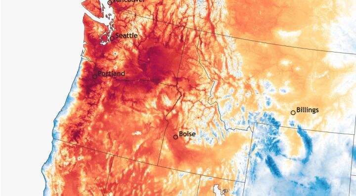
Meteorological analysis of the deadly June 2021 Pacific Northwest heat wave

What was different about the deadly, record-breaking heat wave in June 2021 that made it so much more extreme than anything the Pacific Northwest had experienced before?
Like a doctor diagnosing a patient, Portland State climate scientist Paul Loikith and former PSU master’s student and current Washington State University Vancouver Ph.D. student Dmitri Kalashnikov sought out to provide a detailed meteorological analysis of the progression of the heat wave, comparing the atmospheric conditions associated with the 2021 event with other historical events. Their findings are published in the journal Monthly Weather Review.
“It’s like taking the symptoms and diagnosing what it was that happened to cause something so severe to happen to the system,” said Loikith, an associate professor of geography and director of PSU’s Climate Science Lab. “We looked into a bunch of different factors that have been known to drive heat waves in the region to see if they were there with this heat wave. Were they normal but way more severe, or did something unique happen that we haven’t seen before?”
Loikith said the heat wave, in many ways, shared the same meteorological features and processes as other heat waves in the Pacific Northwest—but every aspect of it was stronger.
The main driver was a large ridge of high pressure, or heat dome. Air sinks under areas of high pressure, which prevents clouds from forming and maximizes solar heating during the day. The ridge was so strong in part because a storm with an atmospheric river—a long, narrow band of water vapor that dumps massive amounts of moisture—had moved into Alaska a week before. When water vapor condenses, it releases heat. The heat accumulated in the atmosphere and caused the ridge to intensify.
“This was more like a wintertime ridge in its physical structure and characteristics, which are bigger than summertime ridges, but occurring just after the summer solstice, we had maximum solar heating and the ability for the air to get really really hot,” he said.
The ridge reached peak strength over southern British Columbia when it was about 10,000 to 15,000 feet above the surface, and warmed at a rate of 10 degrees Celsius per kilometer as it descended to Seattle, Portland and Pendleton.
“The air aloft was cool by human standards, but it’s actually very hot air for that altitude, so when it was brought down to the surface, it was exceptionally hot,” Loikith said.
Stronger offshore winds blowing from the land to the coast also caused the air to warm even more.
What was also interesting, Loikith said, was that the heat wave ended abruptly when a dramatic surge of ocean air displaced the heat in the lower temperature and moved the system eastward.
Loikith said that understanding the range of complex processes that are required to come together for such an extreme event to arise in the first place improves our understanding of meteorology and can help to better model and forecast future events.
“These features coming together in this way will continue to be really rare, but in the future as the climate continues to warm, you will not need as strong of a weather system to make it extremely hot by historical standards,” he said.
More information:
Paul C. Loikith et al, Meteorological Analysis of the Pacific Northwest June 2021 Heat Wave, Monthly Weather Review (2023). DOI: 10.1175/MWR-D-22-0284.1
Citation:
Meteorological analysis of the deadly June 2021 Pacific Northwest heat wave (2023, March 8)
retrieved 8 March 2023
from https://phys.org/news/2023-03-meteorological-analysis-deadly-june-pacific.html
This document is subject to copyright. Apart from any fair dealing for the purpose of private study or research, no
part may be reproduced without the written permission. The content is provided for information purposes only.
For all the latest Science News Click Here
For the latest news and updates, follow us on Google News.

