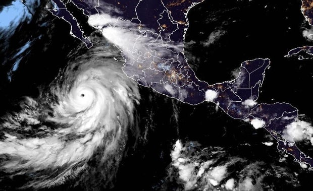
Hurricane Hilary strengthens to Category 4 on path toward Southern California
Hurricane Hilary strengthened to a Category 4 hurricane Thursday night, the National Weather Service said.
The hurricane is expected to hit Southern California with heavy rainfall as early as this weekend after it makes its way up Mexico’s Baja California Peninsula.
Forecasters said the storm is expected to produce 3 to 6 inches of rainfall, with maximum amounts of 10 inches, across portions of Baja California through Sunday night, with the possibility of flash flooding.
There will likely be “damaging wind gusts,” especially at higher elevations, in the area, and swells along the coast, Greg Postel, a hurricane and storm specialist at the Weather Channel, told CBS News.
National Hurricane Center / NOAA
The storm, which isn’t expected to still be a hurricane by the time it reaches California, is forecast to impact the southwestern U.S. with heavy rainfall starting Friday through early next week, “peaking on Sunday and Monday,” according to the National Hurricane Center.
“It is rare — indeed nearly unprecedented in the modern record — to have a tropical system like this move through Southern California,” Postel told CBS News.
The last time Southern California was hit by a tropical storm was in 1939, before storms were given names, CBS News senior weather and climate producer David Parkinson said. Several storms that had been hurricanes or tropical storms have impacted the state since then, but they had weakened to sub-tropical systems by that time, Parkinson noted.
The projected path of the storm showed it could make landfall anywhere from the Baja California Peninsula to as far north as Santa Barbara, California. One model showed the heaviest rain hitting the Palm Springs area after the storm makes landfall.
Thanks for reading CBS NEWS.
Create your free account or log in
for more features.
For all the latest World News Click Here
For the latest news and updates, follow us on Google News.


