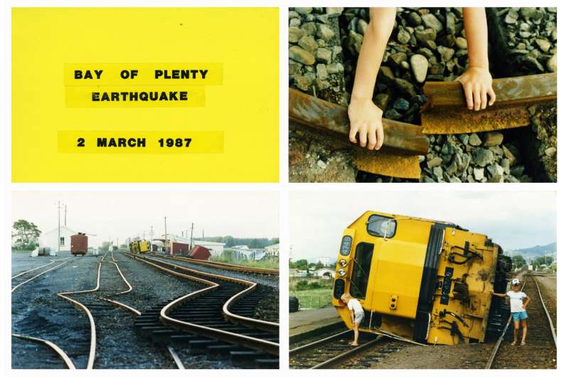
Historic 1987 Edgecumbe earthquake photos contribute towards natural disaster resilience

Research using innovative techniques has revealed the 1987 Edgecumbe earthquake caused more land damage than initially thought, after comparing aerial photos of the landscape before and after the event.
Ph.D. student Jaime Delano, from the University of Canterbury, is undertaking research using old photographs to create 3D models of the Earth’s surface before and after the earthquake. She hopes this method will help scientists better predict damage from future earthquakes.
“Knowing what to expect will help us prepare and the things we learn about older earthquakes gets tied into the new hazard models, which helps us predict the effect of earthquakes on the land,” says Delano.
“Estimating how much the ground will move is tied with how big the earthquake is, either in magnitude or how long the rupture might be. It has a real impact to how we adapt to living with these hazards, because there’s a big difference between knowing the ground will move a few meters compared to 16 meters.”
The magnitude 6.5 shallow earthquake caused great damage in the Bay of Plenty region, severely damaging buildings, distorting railway tracks and injuring 25 people. Delano used aerial photos from the Land Information New Zealand (LINZ) website to create a 3D model of the surface before and after the earthquake.
This meant she was able to measure how much the ground moved and identify further land damage which was missed by researchers in 1987, showing that the earthquake caused larger movements and longer fault ruptures than was recorded at the time.
Dr. Natalie Balfour, Head of Research at Toka Tū Ake EQC believes research like this is valuable for capturing all the learnings from past events so we can better understand the types of damage to expect from future earthquakes. “It’s important to be funding research that improves our understanding of natural disasters.”
“We’ve come a long way, but we know there’s much more to learn. It’s important to consider what we can also learn from previous events. By looking at photos of past events and using this new technique we can gauge how much damage may be caused from future events. This plays a key part in building a more resilient Aotearoa.”
Delano agrees there is more to learn by revisiting previous natural disasters and how they changed the landscape. “I was interested in this research because most of the focus on earthquake hazards is from more recent earthquakes, but it’s important to look back with fresh eyes on previous earthquakes because science and technology is changing and improving so quickly.”
Citation:
Historic 1987 Edgecumbe earthquake photos contribute towards natural disaster resilience (2023, April 10)
retrieved 10 April 2023
from https://phys.org/news/2023-04-historic-edgecumbe-earthquake-photos-contribute.html
This document is subject to copyright. Apart from any fair dealing for the purpose of private study or research, no
part may be reproduced without the written permission. The content is provided for information purposes only.
For all the latest Science News Click Here
For the latest news and updates, follow us on Google News.

