Balancing act: Can precariously perched boulders signal long-term earthquake risk?

The trouble with big earthquakes is that their subterranean root systems can lurk for centuries or millennia before building enough energy to explode. Among many places, this is true of the New York City area, where scientists believe big quakes are possible—but probably so rare, it is hard to say exactly how often they come, or how big they could be.
It was only in the 1970s that researchers began studying the region’s seismicity in close detail. They have mapped many previously unknown faults, and observed dozens of tiny quakes each year, most too small to be felt. The biggest modern quake, a magnitude 4.1 in suburban Westchester County in 1985, did little harm. However, old written records suggest that quakes of about magnitude 5 shook New York and environs in 1737 and 1884. These knocked down chimneys, cracked walls, and shook the ground from upper New England to Virginia. Today, an equivalent event could do great damage to the vastly expanded population and infrastructure of the regional megalopolis. Furthermore, based on the sizes of known faults and the frequency of small quakes along them, some researchers have extrapolated an estimate that a magnitude 6 quake could strike the region every 700-some years, and a magnitude 7, every 3,400 years. A magnitude 6 is 10 times more powerful than the events of 1737 and 1884, and a magnitude 7, 100 times stronger.
But this is just an extrapolation. Have quakes of this size ever actually happened here? No one knows. William Menke a geologist and seismologist at the Columbia Climate School’s Lamont-Doherty Earth Observatory, would like to find out.
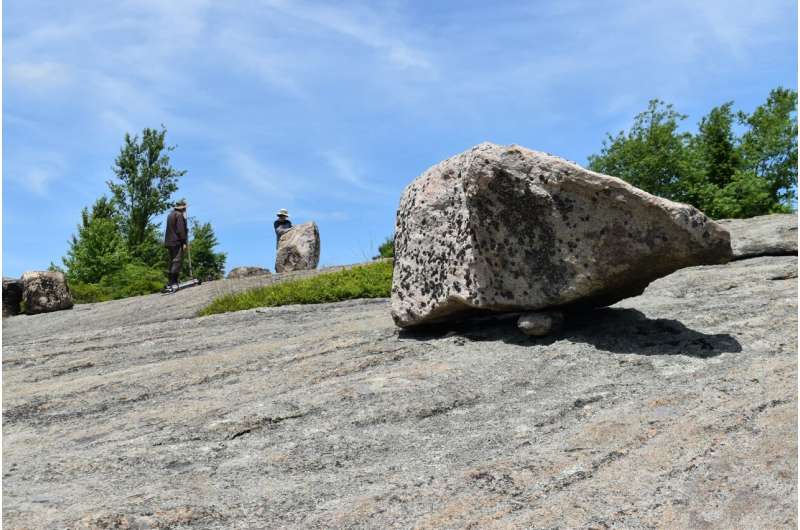
Recently, Menke and a student intern have been visiting Harriman State Park, about 30 kilometers north of Manhattan. Not far from Lamont-Doherty’s suburban campus, the mountainous 47,500-acre reserve contains numerous giant boulders plucked from bedrock by glaciers during the last ice age, then dropped when the ice melted. Some are precariously balanced on one irregular surface or another, presumably still in their original positions. Menke’s mission: calculate how much force it would take to tip them over. If they are still standing, it would suggest that an earthquake of that size has not happened since the ice age ended, well over 10,000 years ago.
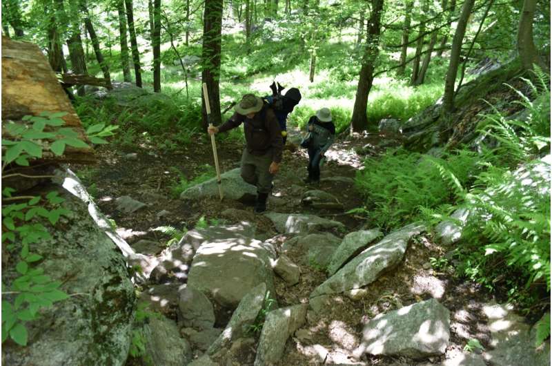
“This would at least place an upper bound on potential ground motion,” said the 67-year-old scientist one morning as he lugged a 40-pound backpack of equipment up a winding, rocky trail. Sun and shade dappled through the tall trees. “Over the years, people have tried to use this method in other places, and I’ve thought we should try it in the Northeast.”
Menke describes himself as “basically, a data scientist.” Since getting his Ph.D. at Lamont in 1982, he has used mathematical data to shed light on a variety of environmental questions, including the propagation of seismic waves and the structure of the earth’s crust and mantle. An avid hiker, kayaker, photographer and all-around observer of nature, his fieldwork has taken him from California to Iceland, and ships in the Pacific Ocean. These days, he largely sticks closer to home, where he has traversed the terrain for decades.

Menke and his intern, Charles McBride, were on their way to study boulders at a previously selected site on Black Rock Mountain, an hour-long trek from the nearest road. The site is just three miles from the Ramapo Fault, a 185-mile-long feature that cuts through Pennsylvania, New Jersey and southern New York state, slashing through the middle of the park. It produces many of the region’s small earthquakes, and could be major candidate for producing past big ones.
On the way, Menke stopped to admire blooming patches of mountain laurel, and kept a low-key eye out for rattle snakes. “You don’t see that many rattlers. I’ve only seen eight, and those were all in the last eight years,” said Menke.
The study of past earthquakes is called paleoseismology. Its practitioners may study accounts from old newspapers, diaries and histories, but in many places including the U.S. Northeast, these go back only a few hundred years—not far enough to provide a truly long-term picture.
To reach into prehistory, some paleoseismologists dig a trench (or better, wait for someone to dig a house foundation) and observe whether buried layers of soil have been displaced against each other. This indicates a past movement, which can be dated using carbon isotopes. In the U.S. Northwest, researchers have used rings from long-dead trees to pinpoint earthquakes that dropped them into lakes or saltwater marshes and killed them. A study earlier this year by some of Menke’s Lamont colleagues used variations in the chemistry of ancient rocks two miles below the surface to show that a supposedly quiescent section of the San Andreas Fault has seen major past quakes.
The study of precariously perched boulders and similar features is still young. In the early 1990s, California-based geologist James Brune began surveying precarious rocks. He got his first validation in 1999 in the Mojave Desert, when a magnitude 7.1 earthquake toppled several that he had previously targeted as susceptible. Scientists in the western United States began investigating other so-called fragile geologic features for paleoseismology potential: sea stacks along the Pacific Coast (slender rock towers carved out by wave erosion); desert hoodoos (rock spires whose bases or middles have been precariously undermined by wind); tufa towers (crumbly pinnacles of limestone formed by underwater chemical processes in onetime lakes, now dried up). Scientists in Australia and earthquake-prone New Zealand have carried out similar research.
In California, some researchers have shown that features that should have been toppled by prehistoric quakes predicted by computer models similar to ones employed in New York are still standing. This suggests that standard attenuation curves—calculations of how often and how much the ground shakes—may be exaggerating long-term hazards, at least in some places.

“I suppose to some extent you could say that is good news,” said Menke. On the other hand, he said, “there are some gaps in the knowledge.” The generally loose, cracked-up rocks in quake-prone California are actually quite poor at transmitting seismic waves to the surface, and thus may end up muffling earthquakes. The New York region, on the other hand, is largely underlain by hard metamorphic rocks that can ring like a bell. That means smaller quakes in this region could translate into bigger ground motions. “The California curves are not applicable to our work,” he said.
As Menke and McBride ascended the mountain, the landscape changed to a kind of rolling semi-tundra. Trees shrank to wind-blown shrubs. Domes of naked gneiss and granite bedrock occupied high spots, where ice sweeping from the north long ago scoured the surface, and plant life has never returned. Giant boulders were scattered about.
A study by one of Menke’s Lamont colleagues using the initial presence of pollen cored from the bottoms of bogs says these boulders were dropped from melting ice about 14,000 years ago. Another colleague who instead measured chemical isotopes in rock surfaces says it was more like 22,000 years ago. The use of precarious boulders in paleoseismology is a simple concept—but the execution is complex. The lack of a clear origin date for boulders’ positions presents one of many uncertainties.
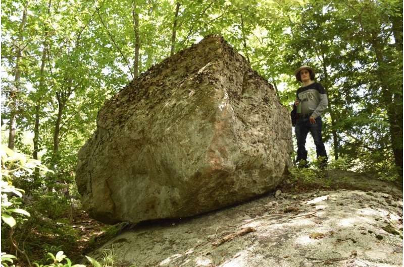
To reduce at least one uncertainty, Menke and McBride were looking for boulders too big to have been moved by human hands, and on a previous reconnaissance they had quickly hit pay dirt, so to speak. Along the trail, Menke pointed out several giants that he planned to investigate. One, about the size of an ultra-compact car, rested on a slender base with one side forming a wide, overhanging shelter where piles of ashes showed that passers-by had built camp fires. Another, much larger, teetered at the sloping edge of a bedrock dome. “Look, part of its underside is just air,” said Menke. “If you shook it, it could easily slide down into the trees, but it hasn’t. Yet.”
Menke was also scouring the area for exposed earthquake faults, but admitted he had not seen anything conclusive. At one juncture, he pointed out a squiggly, 20-foot crack in the bedrock. It looked like minerals had long ago filled in whatever void had once existed. He speculated it could be a minor fault that had formed underground millions of years ago. Or, maybe it was just a plain old crack.
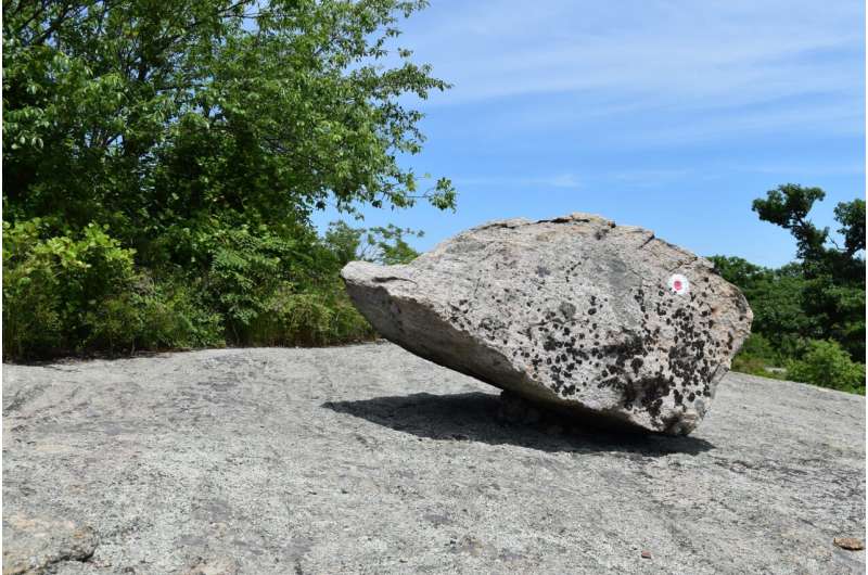
Presently, Menke and McBride emerged into a summit area composed mainly of naked outcropping gneiss. A bunch of precarious-looking boulders were scattered about. They approached one vaguely egg-shaped chunk of granite about four feet high, resting on one of its narrow ends. Menke estimated it weighed about 3 tons. He surmised it had been torn out by moving ice from maybe three or four miles away before ending up here. This was to be their main quarry for today.

To date, most researchers have used hand measurements to calculate the mass and stability of such boulders; a few have tried wiggling rocks slightly by mechanical means to get a sense of their balance. Menke was employing a newer approach: photogrammetry, the creation of a 3D model of an object by taking numerous photographs of it from various angles. The photos are then fed into a computer model, which can be used to calculate the boulder’s mass, weight distribution, balance points, and the forces of various kinds and magnitudes that could dislodge it. Menke was considering a further step: using the data to print physical replicas of boulders, which he could then subject to various kinds of shaking in the lab to see what happened.
After a quick lunch, Menke and McBride set about chalking out on the bedrock a circle of 16 equally spaced points 20 feet from the boulder. From here, they planned to take an initial set of photos, all focusing on the same level of the boulder in relation to the ground. Several of these photo circles at various distances would go into creating the 3D model. After a few false starts, they started snapping photos with Menke’s Canon, its elevation carefully calibrated on a tripod for each shot.
Getting everything lined up for each shot took quite a bit of time. A broiling midday sun beat down and reflected off the bedrock surface, and off Menke’s bare head, but Menke and McBride did not seem to notice. McBride stopped to take a swig of water once or twice, but those were almost the only breaks.
They continued until 4:30, at which time the sun continued at full blast. By then, the pair had still not completed even the first circle in the detail they had desired. They took a few shortcuts to produce more shots. Menke finally sat down on a nearby un-precarious boulder while McBride packed up. “Well, we’re a little behind, but that’s enough for one day,” he said. “We’ll definitely get faster with practice.”
In any case, the photos would only be the start, he said. The real work would come in modeling what kinds of ground motions earthquakes around here might produce, what directions and from how far off they might come from, and how this particular boulder would react. This, of course, was only the first of many boulders.
On the hike back, Menke paused by a particularly spectacular patch of mountain laurel. He pulled out his cell phone and took a panorama of the flowering shrubs—a sort of living photogram. “We have lots of time up here. These flowers just last a few days,” he said. Shoving the cell phone back in a pocket, he grinned and headed down the trail.
A slow-motion section of the San Andreas fault may not be so harmless after all
Provided by
State of the Planet
Citation:
Balancing act: Can precariously perched boulders signal long-term earthquake risk? (2022, July 22)
retrieved 22 July 2022
from https://phys.org/news/2022-07-precariously-perched-boulders-long-term-earthquake.html
This document is subject to copyright. Apart from any fair dealing for the purpose of private study or research, no
part may be reproduced without the written permission. The content is provided for information purposes only.
For all the latest Science News Click Here
For the latest news and updates, follow us on Google News.

