Scientists have developed a new model of Earth’s tectonic plates that provides fresh insights into the planet’s geological history and a better understanding of natural hazards like earthquakes and volcanoes.
The research, published in the journal Earth-Science Reviews, provides a better explanation of the spatial distribution of earthquakes and volcanic eruptions in Earth’s history.
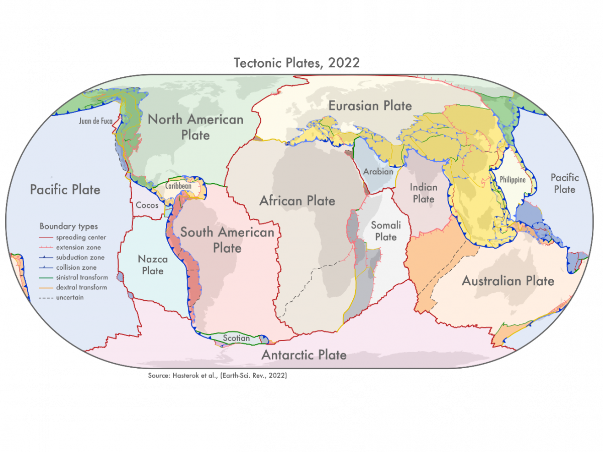
“Our new model for tectonic plates better explains the spatial distribution of 90 per cent of earthquakes and 80 per cent of volcanoes from the past two million years, whereas existing models only capture 65 per cent of earthquakes,” said Derrick Hasterok, a lecturer with the Department of Earth Sciences at the University of Adelaide.
In the study, scientists produced three new geological models – a plate model, a province model, and an orogeny (mountain formation) model.
“There are 26 orogenies – the process of mountain formation – that have left an imprint on the present-day architecture of the crust. Many of these, but not all, are related to the formation of supercontinents,” Dr Hasterok said.
Supercontinents, notably Pangaea, Gondwana, and Laurasia, are large land masses in Earth’s history thought to have divided to form the present continents.
The new model, according to the scientists, includes fresh microplates such as the Macquarie microplate that sits south of Tasmania and the Capricorn microplate which separates the Indian and Australian plates.
“These new plate models show improved correlation to observed earthquake and volcano occurrences within deformation zones and microplates, compared to existing models, capturing 73 and 80 per cent of these criteria, respectively,” they wrote in the study.
Researchers added more accurate information about the boundaries of deformation zones since previous models showed these as discrete areas rather than wide zones.
“The biggest changes to the plate model have been in western North America, which often has the boundary with the Pacific Plate drawn as the San Andreas and Queen Charlotte Faults. But the newly delineated boundary is much wider, approximately 1500km, than the previously drawn narrow zone,” Dr Hasterok explained.
“The other large change is in central Asia. The new model now includes all the deformation zones north of India as the plate bulldozes its way into Eurasia,” he added.
Scientists say the newly updated model can be used to improve models of risks from geohazards such as earthquakes and volcanic eruptions.
“The orogeny model helps understand the geodynamic systems and better model Earth’s evolution and the province model can be used to improve prospecting for minerals,” Dr Hasterok said.
For all the latest Science News Click Here
For the latest news and updates, follow us on Google News.