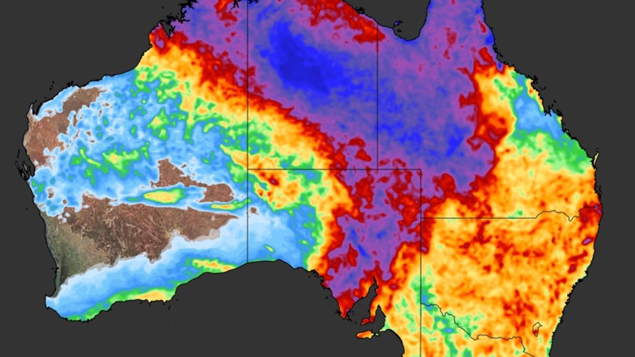
An entire summer’s worth of rain could fall in parts of the country this weekend raising flood fears while a heatwave scorches four states.
There are “serious concerns” for large areas of South Australia as a prolonged and heavy rain event parks itself above the state this weekend.
A severe weather warning is in place for a large chunk of SA with fears that rain levels not seen for a century or more could lead to widespread flooding.
Elsewhere, heat is the issue, with Perth looking at a record-breaking run of days north of 40C and heatwave conditions for Melbourne and Tasmania, as well as Adelaide.
Moisture and heat mean another pain. Humidity, and lots of it.
“Across many parts of Australia at the moment the threat is either a heatwave or heavy rainfall,” said Sky News Weather meteorologist Rob Sharpe.
Tropical moisture swirling around the country has led to a slow moving trough over central Australia.
“It will crawl across South Australia sliding to the east with heavy rain and flooding,” said Mr Sharpe.
“It’s a serious concern, with 50 to 100 millimetres of rain and more than 100mms in parts of the Northwest Pastoral and some neighbouring areas.”
That could mean an entire summer’s worth of rain will fall in parts of SA over just a few days.
The Bureau of Meteorology (BOM) has issued a severe weather warning for people in the Eyre Peninsula and parts of the West Coast and Northern pastoral districts for heavy rainfall and storms that could lead to flash flooding over the weekend.
The washout is already happening. Ceduna, 800kms west of Adelaide, saw 45mm of rain in the 24 hours to 9am on Friday. An average January sees just 9mm fall. Wirulla, a small town east of Ceduna, registered 110mm in one day which hasn’t been seen in more than 100 years.
The forecast for Adelaide has ebbed and flowed over the last few days. It’s at the edge of the system and it had been thought the city would miss much of the moisture.
But current projections suggest there could be downfalls beginning on Saturday night and then as much as 20mm falling on the CBD on Sunday.
It could be scorching as well in Adelaide which is at the far end of one of two major heatwaves baking parts of the continent this weekend.
The city could totter around maximums of 35C until Sunday when the mercury could drop to 28C. Next week will see maximums consistently around 30C. Early on Saturday morning it won’t dip below 25C.
Southern parts of the Northern Territory could also be hit by the rain. Alice Springs could get 15-25mm in the gauge on Saturday and up to 30mm on Sunday.
Heatwave for Victoria and Tasmania
The heatwave extends into Victoria and Tasmania meaning the whole of the country’s south could see warmer than average conditions.
The BOM’s definition of a heatwave is unusually hot maximum and minimum temperatures over a three-day period at a location.
“It will build up a little bit more for Melbourne as it eases back to Adelaide over the next few days,” said Mr Sharpe.
“It’s going to be a fairly long lasting heatwave for Tasmania and Victoria and it’s going to become even more humid into next week.”
In Melbourne, the mercury will peak at 33C on Saturday and Sunday and then climb to 34C on Monday. Overnight lows will be around 20C this weekend.
It will be dry in Hobart and getting warmer. A high of 26C on Saturday and then hitting 27C on Sunday with mid-teen minimums.
Record breaking, blisteringly hot weekend in Perth
But it’s Perth that tops the leaderboard for most oppressive state capital. Saturday could reach 40C with Sunday not much cooler at 37C. Next week Perth will cool, but only down to the low thirties.
“This summer, the West has seen eight days over 40C, and we’re likely to see at least one more over the next couple of days,” said Mr Sharpe said on Friday.
“Eight is already a record for the summertime. But this individual heatwave is also potentially record breaking. We’ve seen four days in a row now above 40C up to Friday.
“On Saturday the sea breeze will come in slightly earlier so it’s touch and go whether or not we’ll have a fifth day in a row over 40C,” he said.
“But if we do, it’d be the first time on record for Perth.”
Head further north and its gets even hotter. Exmouth could see 46C on Sunday.
NSW, Queensland, NT and the ACT
The weather is warming up in Canberra, with a high of 25C in the capital on Saturday and then 27C on Sunday and Monday and hitting 30C on Tuesday. Minimums should be around 11C.
Sydney is now stuck around the 25-27C high level for the weekend, with warmer days next week but still within the average temperatures for January.
Some rain in Brisbane but only light falls for the weekend. Temperatures will stall around the 28C mark and 20C at dawn until the weekend is done. The mercury could well shoot over the 30C hurdle on Tuesday.
Darwin will see heavy rain and storms most days with between 10-20mm of rain. The city will top out at 32C.
Originally published as Weekend weather: ‘Serious concerns’ as major rain event takes hold while heatwaves scorch four states
For all the latest Technology News Click Here
For the latest news and updates, follow us on Google News.

